

The heat index—a measure of temperature in conjunction with humidity—has risen to dangerous levels over the past month, but the greater Houston area is expected to receive a cold front as the calendar turns to September.
The National Weather Service forecasts that temperatures in Huntsville will drop into the low 70s this weekend, with the possibility of storms Friday through Sunday. There is also a 40 percent chance of thunderstorms on Friday night in Houston, where SHSU’s football team is set to play its 2025 home opener.
It’s rare to see a cold front pass through southeast Texas in the month of August. According to Meteorologist Dr. Robert Gauthreaux III, an assistant professor of practice in Sam Houston State University’s mass communication department, Texas has dew point temperatures of 70-75 degrees during the summer. This results in hot muggy weather.
The dew point is expected to drop to around 65 degrees during the upcoming cold front.
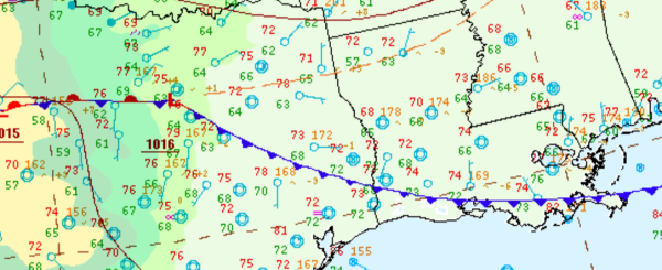
Below is a weather diagram that showcases a cold front which moved into the Walker County area Tuesday morning.
End of the Week
The National Weather Service forecasts a 40 to 60 percent chance of rain showers and thunderstorms throughout the weekend. A high of roughly 90 degrees is expected on Saturday, with lows predicted to drop into the mid-70s, according to Space City Weather.
Sunday
Humidity levels should begin to fall by Sunday, which Gauthreaux predicts could cause the temperature to drop to 69 degrees by Tuesday morning. Sunday’s NWS forecasts indicate a high in the mid-80s with a 40 percent chance of precipitation.
Sunny skies are expected to return on Labor Day, as temperatures are forecasted to range from 88 at the peak of the day to around 70 degrees at night.