
UPDATE: As of 9:30 a.m. Saturday…
The reason for freezing rain and sleet is because of some robust warm air aloft in the atmosphere, high above the ground. As snow high in the atmosphere above Huntsville begins to fall, it will melt through this warm layer of air, cooling again as it approaches the ground. As it cools, it will either fall as supercooled water (freezing rain) or refreeze as ice (sleet).
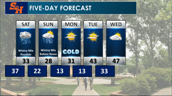
Sunday morning will begin with a wintry mix, with perhaps even a few snowflakes mixed in as the temperature continues to drop, but we’re not expecting snow to accumulate on the ground. By late Sunday morning or into the afternoon, ice remains, but drier conditions prevail with mostly cloudy skies and perhaps a little sun even peeking through.
Due to the forecast calling for multiple days before freezing, travel impacts will be felt Monday as ice remains in areas, especially bridges, overpasses, and rural roads. It’s possible some impacts may even linger into Tuesday morning in areas around and including Walker County.
UPDATE: As of 3 p.m. Friday…
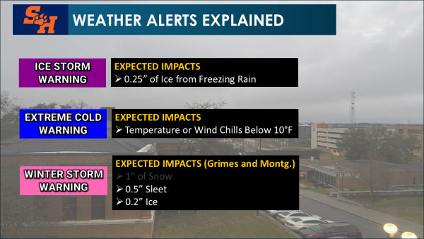
The National Weather Service in Houston officially issued Extreme Cold Warnings for Walker County and surrounding areas on Friday. In addition, Ice Storm Warnings have been issued across Walker, Madison, Houston, Leon, Trinity, Polk and San Jacinto counties.
The NWS has also issued Winter Storm Warnings for Grimes and Montgomery counties.
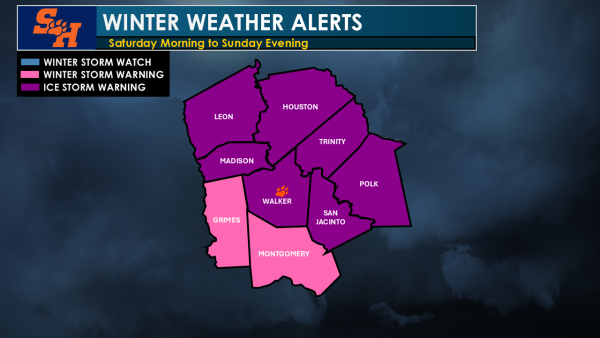
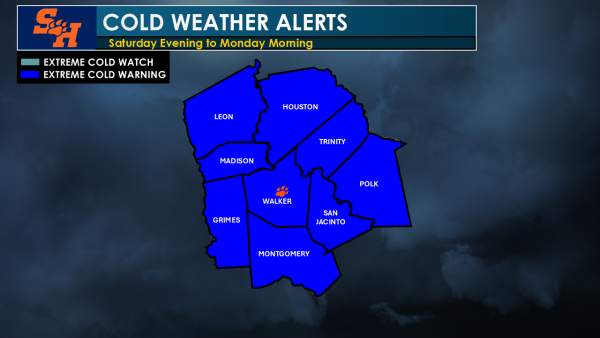
Extreme cold warnings are issued when temperatures or wind chills are expected to be in the single digits within 24 to 36 hours. Ice storm warnings are issued when ice accretion greater than 1/4 inch of ice is expected due to freezing rain. Winter storm warnings are issued, specifically for Grimes and Montgomery counties, when at least 0.2 inches of ice or 0.5 inches of sleet is expected within 24 to 36 hours.
Forecasts from the NWS reveal that the cold front is now entering North Texas, indicating that it will pass through the area of Huntsville later Friday evening.
Looking Ahead into the Weekend’s Conditions
Freezing rain and ice are the primary hazards of this weekend’s storm for Huntsville and Sam Houston State University, Meteorologist and SHSU faculty Dr. Robert Gauthreaux III said.
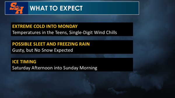
Regarding what residents can expect on Saturday, Gauthreaux explained that its warmest temperatures will appear soon after midnight and drop steadily throughout the day. The afternoon will likely drop to the mid to low 30s, only to fall further into the mid to low 20s during the night, branching into Sunday morning.
While rain will continue Friday going into Saturday, the timing of the transition into freezing rain or sleet is during Saturday’s p.m. hours. Gauthreaux finds that these conditions could appear as early as the afternoon, but “certainly overnight and into the morning hours on Sunday.”
As such, icy roads may persist into Monday, especially if temperatures do not rise above freezing on Sunday afternoon.
As The Houstonian has been monitoring this storm, temperatures do appear to be a little colder than what was anticipated earlier in the week, and subfreezing temperatures all day on Sunday look more feasible with a forecast high temperature of 28 degrees.
The NWS additionally reports that the probability of freezing rain in Huntsville is approximately 70% to 90%, with 1/10 inch or more of ice possible, but high-end estimates are up to 0.3 inches, hence the ice storm warning.
Local Residents to be Advised
Residents are advised by the NWS to remain aware of the likely hazardous travel conditions this weekend and to adjust commutes as needed.
Rain on the road throughout the day on Saturday will complicate transportation as temperatures are expected to drop below freezing in the hours following. This includes bridges and overpasses, which Gauthreaux notes become particularly dangerous due to the fact that they freeze sooner than other surfaces. Icy conditions on less-traveled, rural roads in the Huntsville area could also pose a danger to drivers.
In the event that temperatures do not climb above freezing on Sunday night, adjustments to commutes may be necessary on Monday as well.
At this time, Gauthreaux predicts a low temperature of 13 degrees on Monday morning, paired with wind chills into the single digits.
Further updates will be provided on The Houstonian, 90.5 The Kat and KSHU Cable Channel 7 through Saturday.