
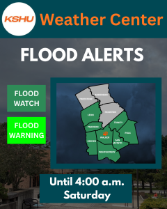
A flood watch has been issued until 4 a.m. Saturday morning for Walker, Trinity, Madison, Leon, Grimes, Polk, San Jacinto and Montgomery Counties. A flood watch is issued by the National Weather Service when there is a potential (50 to 80%) chance for life-threatening flooding/flash flooding in the next 48 hours due to either rainfall or the possibility of dam failure.
Impacts of potential flooding include excessive runoff that can flood rivers, creeks, streams and other low-lying, flood-prone areas.
Waves of showers and storms will produce localized high rain rates and the potential for several inches of rain in a short time period. Forecast estimates through Saturday morning are 1-3 inches, with localized higher amounts.
Be aware of the following flooding trouble spots around Huntsville: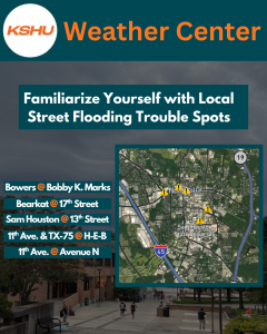
- Bowers Boulevard. @ Bobby K. Marks Drive
- Bearkat Boulevard @ 17th Street
- Sam Houston Avenue @ 13th Street
- 11th Avenue & TX-75 @ H-E-B
- 11th Avenue @ Avenue N.
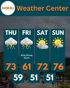
Thunderstorms are expected periodically. However, the risk for severe weather remains relatively minor on Thursday. We could see a slightly better chance for a stray severe storm Friday, but overall, chances still remain fairly minor.
This is all in response to a robust cold front that has stalled along the Gulf Coast. This front will bring unseasonably cool air this weekend, starting off the beginning of May well below average. Highs will struggle to reach the 70s, as low temperatures may even dip into the upper 40s.
Record-breaking low temperatures for May are not expected. The coldest temperatures recorded at Bruce Brothers Huntsville Regional Airport on May 2 (2014) and May 3 (2013) are 46 and 44 degrees, respectively.
However, it is quite possible we could experience not only the coldest May 1 high temperature on record in Huntsville, but possibly the coldest high temperature for the entire month of May. The forecast high for Friday, May 1, is 61 degrees. The coldest high temperature on record for May 1, according to the National Weather Service, is 60 degrees (1994). The coldest high temperature for the entire month of May is 56 degrees, set on May 7, 1917.
While National Weather Service records for Huntsville stretch as far back as 1903, these are not always the most reliable for climatological analysis. If we look at the reliable Bruce Brothers Huntsville Regional Airport Data stretching back to 1997, the record coldest high temperature for May 1 is 72 degrees, set in 2004. The coldest high temperature in May on record was set on May 2, 2011, at 65 degrees.
What this means is this upcoming cold snap could very likely make the high temperature for Friday, May 1, the coldest on record. While long-term records dating back to 1903 show the coldest high temperature for the entire month at 56 degrees, more reliable airport data since 1997 sets the bar lower with a temperature of 65 degrees. Either way, this would be an unusually cold start to the month.
Lastly, Wednesday’s severe weather did produce a few storm reports of large hail in nearby counties. The closest to Huntsville was quarter-sized hail outside Midway in Madison County, while the largest was golf ball-sized hail east of Fairfield in Freestone County.